
Mexico is pretty big, in fact it is the World’s 13th-largest country by area. It consists of 32 states. Here, I will teach you how to to choose what places to visit in Mexico and when. And at the end, I will share a 6 month Perfect Weather Roadmap in Mexico. The roadmap lets you have the maximum flexibly while traveling, as it is not limiting you to only one route. Instead, it offers multiple choices, allowing you to be your own travel agent.
| If you find my work worthwhile, drop me a few 🪙🪙🪙 Venmo Me It will allow me to keep writing content like this! |
First, we looked at the climate.
While looking on the map, we noticed how much of Mexico territory is actually a harsh desert. Ouch!
Desert-like states in the north, besides California, New Mexico and Texas that are now part of the United States, were always scarcely inhabited. Could it be the reason why American Army had no trouble marching to Mexico City during Mexican-American War of 1846-1848?

Mexico climate and landscape is desert-like in the north, tropic-like in the south and mild and wonderful in-between. This “in-between” is the true heartland of Mexico with it’s perfect weather, crazy history, mind-bending archeology and colorful traditions. It might come as a surprise, but it is mostly “in-between” is where ancient civilizations rose and fell.
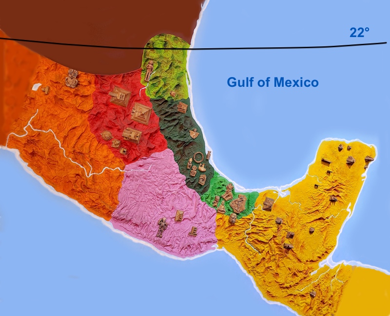
Well, the 22 degree parallel seems as an agreed upon orienteer by many published travelers for separating frigid territories to the north. Removing the states above that line alone cuts the state count almost in half.
Then, we looked at the country’s crime rates.
Is Mexico safe? Mexico territory is divided into 32 states. Some states are safer to visit than the others. Each state safety level is directly related to the prosperity level of its population or the lack of it. Poverty pushes desperate people to become worse versions of themselves. Traveling through a poor state is NOT fun!
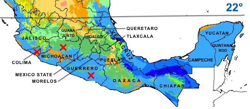
We visited Travel.State.Gov for the current travel advisory for Mexico and removed Colima, Guerrero, Michoacan states from our already shortened list.
Now, we chose cities.
Ok, after we selected potential states to visit, we were ready to look at the city level for each state. Also, while traveling, we want to include an occasional visit to a beach. So, whenever possible, we added some beach towns into the list of cities to explore.
| State | Cities to start with for state exploration |
|---|---|
| 1. Jalisco | Guadalajara – the second largest city in Mexico Puerto Vallarta – a beach resort town |
| 2. Guanajuato | Guanajuato San Miguel de Allende |
| 3. Querétaro | Querétaro |
| 4. Hidalgo | Pachuca |
| 5. San Luis Potosi | San Luis |
| 6. Veracruz | Veracruz – a port and a beach city Orizaba Xalapa |
| 7. Tlaxcala | Tlaxcala |
| 8. Puebla | Puebla |
| 9. Mexico State | Mexico City – the biggest city in both Americas! Toluca – coolest of all due to altitude (freezing during winter nights) |
| 10. Morelos | Cuernavaca |
| 11. Oaxaca | Oaxaca Puerto Escondido – a beach resort town |
| 12. Chiapas | San Cristóbal |
| 13. Yucatan | Merida – almost a beach city, 30 miles to the nearest beach |
| 14. Quintana Roo | Cancun – a beach resort city |
Look how many states in Mexico offer great adventures! You can stop here and explore any cities on the list and more, or you can get pickier and set some low temperature limit, as did we (in the next step).
Finally, we built our Perfect Weather Roadmap.
We were planning on staying in Mexico for about 6 month during the winter of 2021-2022. Because it was the coldest part of the year, we ignored records on high temperatures. Even the hottest places in Mexico were at their mildest in winters. Instead, we would prefer not to get too cold. So, we set ourselves a limit on how cold the area can be during the night for us to enjoy it. We would comfortably stay above 50F (10C) for the nightly low temperatures.
We found wikipedia of great help, as it posted the temperature tables almost for all the cities on our list.
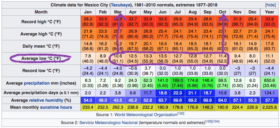
Source 2: Servicio Meteorologico Nacional (temperature normals and extremes)
As an example, the table above is what wikipedia publish for Mexico City. We looked at Average Low, and added the city name (Mexico City) under each month it is above our limit of 50F (10C). In Mexico City case, the months were March and October. We also added the second half of February and the first half of November as well, expecting that this limit will still partially work. In total, Mexico city got 4 entries (in bold in the table below).
We repeated the process for every city on our list and, TA-DA, we got our Perfect Weather Roadmap!
| Month/Cities | All Month | 1-15 of the month | 15-30 of the month |
|---|---|---|---|
| October | Guadalajara Querétaro Guanajuato San Miguel de Allende Pachuca San Luis Tlaxcala Puebla Mexico City Cuernavaca San Cristóbal Merida | Toluca | |
| November | Guadalajara Orizaba Xalapa Cuernavaca Oaxaca Merida | Guanajuato San Miguel de Allende Querétaro San Luis Puebla Mexico City | |
| December | Guadalajara Orizaba Xalapa Cuernavaca Oaxaca Merida Veracruz Any Beach Town | ||
| January | Guadalajara Xalapa Cuernavaca Oaxaca Merida Veracruz Any Beach Town | ||
| February | Guadalajara Orizaba Xalapa Cuernavaca Merida Veracruz Any Beach Town | Querétaro Mexico City San Miguel de Allende | |
| March | Mexico City Guadalajara San Miguel de Allende Querétaro Orizaba Xalapa Puebla Merida | Cuernavaca | Guanajuato San Luis Toluca |
Now are were ready to comfortably explore Mexico by visiting any city of our choosing at its best time. And so can you! Enjoy!
Do you like my posts? What until you see my quests! If you ever decide to visit Acadia National Park, check out my book available on Amazon as paperback and Kindle editions. Buy a book, change a life! Thank you for your support and patronage.
Copyright © 2022 by E.Gra. Unless otherwise noted, all rights reserved. Unless otherwise indicated, no part of this work may be reproduced, or transmitted in any form or by any means without the author’s prior written consent.